Heads: Laurent Hauswirth and Rami Langar.
This area is a major application domain of the Bézout Labex, in line with our integration within the I-SITE FUTURE project.
Urban Modeling
Digital models of buildings and cities are becoming fundamental tools for the development and maintenance of urban areas. They can be used by architects and urbanists as visual aids to design or redesign a neighborhood. But, more importantly, they can also be used to support quantitative studies involving simulation and optimization, such as studying the impact of traffic regarding the diffusion of sound (noise disturbance) and aerial pollution (e.g., carbon monoxid), solar potential (e.g., to identify where solar cells can be installed on roofs), shadow casting on neighboring buildings (e.g., before constructing a new one), street lighting (to optimize illuminated areas while reducing consumption), street wind maps, etc.
At a finer-grained scale, Building Information Modeling (BIM) is revolutionizing the way buildings are designed, constructed, maintained and deconstructed. Applications include studies on thermal performance (e.g., to find the best insulation options and implementations), noise diffusion, natural lighting, augmented reality and progress inspection at construction sites, conformity analysis for accessibility or security (e.g., for evacuation), etc.
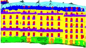
These applications require to know not only the 3D geometry of cities and buildings, but also their semantics. Reasoning on cities thus requires locating constructions, streets, sidewalks, urban vegetation, etc. Likewise, operating on buildings requires identifying walls, openings (windows and doors), roof parts, etc., and possibly equipment too such as heaters, pipes, plugs, etc. Related to semantics is structure diagnosis, to detect and inform about defects such as cracks, exposed reinforcement, delamination, etc.
Researchers in Bézout have long been working on 3D reconstruction from photographs, more recently from range data captured by lidars, using and developing tools of projective geometry and computational geometry for computer vision. A successful start-up company, Acute3D, was created in 2011 to transfer the 3D reconstruction technology, and was bought in 2015 by Bentley Systems (a company that develops software and services for the design, construction, and operation of infrastructure). Yet, a number of issues are still unsolved, in particular regarding the reconstruction of building interiors where the lack of texture (walls and ceilings with uniform colors) and the brutal variations of viewpoints when crossing door thresholds cause current photogrammetric methods to fail. The joint reconstruction of both building interiors and exteriors also raises issues related to data heterogeneity (photos vs laser scans, ground-level vs aerial views from UAVs, planes or satellites) and data incompleteness, as they are many occluded parts in a building or city, that cannot be practically observed.
Besides pure geometry, a number of results have also been achieved regarding building and city semantization, using mathematical tools such as parsers for shape grammars and Markov Random Fields (MRFs). More recently, the labex has also developed efficient techniques based on deep learning for object detection, recognition and segmentation, with applications to cityscapes as well as structural defects diagnosis. A significant challenge for the coming years is to be able to jointly analyze the geometry and semantics of buildings and cities. Machine learning and in particular deep learning will play an important role for that, not only for semantization but also to take decisions in the geometry reconstruction process for the frequent issues of noisy and incomplete data.
Digital Construction and Maintenance
Another emerging and promising topic in Bézout is robot-aided construction and maintenance. It leverages on current Bézout expertise in computer vision and machine learning (especially in deep learning), in association with the Navier lab for structure and construction issues.
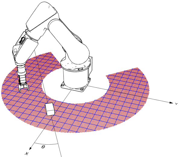
Two joint PhDs between LIGM and Navier have started on autonomous masonry construction using structurally innovative ashlars and on mobile and collaborative robotics on construction sites. Actual operative robotic arms and tracks that can operate on construction sites are available to experiment with.
This topic, which also includes additive construction and visual inspection of infrastructure, is extremely broad. New practical problems have arisen which in turn raise both mathematical and structural issues, e.g., how to create openings when 3D-printing a building with concrete, how to reinforce aging bridges thanks to an automated visual and acoustic diagnosis as well as composite 3D-printing, or how to inspect tunnels and railway equipment using images taken at high speed not to disrupt commercial traffic.
Our goal, in association with Navier, is to become one of the main research players worldwide on digital construction and maintenance.
Architecture and Structural Mechanics
With the emergence of new materials and digital tools in the late 1990s, design offices allowed architects to construct buildings with slender shapes (NURB). However, the needs of artistic expression leads to the exorbitant cost of certain constructions. Sustainability concerns also raise the issue of the economy of means. In the last years, differential geometry has proposed effective new solutions for the optimization of forms. A new field named “Architectural Geometry” recently emerged, which organizes conferences every two years.
Our objective is to reverse the “constructed from design” concept into a “designed for construction” paradigm. We want to offer to the architect numerical tools that allow a great freedom of design while softly constraining the designer in a collection of optimal and constructible forms. The challenge here is not to curb creativity but to allow a freedom to invent while reducing costs, and in particular ecological costs. As mechanical issues are also major concerns in shape optimization, interdisciplinarity is required.
We are looking for forms that allow optimal constructions. The change of scale between a surface model and a building constructed with panels that include insulation, windows and beams requires a fine geometry analysis. In particular, it is necessary to construct surfaces which admit offsets, i.e., a parallel surface at a given distance. We rely here on shells and plates with double radius of curvature, i.e., when Gaussian curvature is not identically zero. We also want to favor construction with quadrilateral panels rather than triangular, to reduce the complexity of the node connectivity. Indeed, it is easier to connect 4 beams on average for quad surfaces, than 6 on average in triangulated surfaces. However, quadrilateral planarity requires studying the forms with a good knowledge of the lines of curvature. For this, we are considering parameterizing isothermal surfaces by orthogonal coordinates along lines of curvature.
A research group has formed on this topic, with a number of researchers from LAMA, CERMICS and Navier, around the supervision of two PhD students, one in mechanics and one in mathematics. The collaboration is extending with three new PhD students who have started their thesis in 2017, co-funded by LABEX MMCD, ENPC, ETH Zurich and by design offices of Bouygues and T/E/S/S (Pavillon Vuitton).
Urban Networks
In line with the research areas of Bézout, we also do research on urban networks in a broad sense, including mobility modeling and prediction, mobility-usage correlation studies, urban sensing strategies, and big-data management and analysis. These topics take part in the foundations of a smart city system. Three main application areas are currently targeted: smart grid management while making use of electric vehicles, traffic offloading to avoid congestion in the communication infrastructure, and seamless service provisioning to the users by dynamically placing content and servers in the “Cloud”, close to the denser access points upon prediction and detection of massive people displacements.
A first subject of study concerns sensing, i.e., the collection of the state conditions of the city as well as its main points of interest, e.g., areas receiving the crowd attending a big event. It covers multiple elements composing the city, from individual players (e.g., citizens and vehicles) to infrastructures (e.g., electrical grid, communication infrastructure, public transportation system) to social networks (e.g., Facebook and Twitter). Such a measurement system involves inputs from the individual players through participatory sensing, from centralized authorities in a managed way, and from social networks through analytics techniques. Ideally, sensed information needs not only to cover a significant fraction of the city but also to be collected in a regular fashion to have a temporal meaning. With this regard, one of the main issues is how to understand the dynamics of the city to determine the correlation between user mobility and content consumption. Another issue is how to deal with incomplete and unreliable data.
Information sensing generates massive amounts of data whose management raises challenging scalability issues. Another research subject concerns innovative approaches to address this problem of urban cloud-based data analysis, including correlating information from different sources and the detection or discovery of patterns that characterize the behavior of users or cities as a whole. Once a city is characterized, services can be adapted to the needs of specific scenarios, e.g., for smart grid management, traffic offloading, or mobility- and usage-aware service provisioning. A related issue is making recommendations concerning key elements in the city, to make service adaptation more efficient.
Efficient Transport Systems
The NICT have had a great impact on mobility, and especially on city mobility. Transport on demand, bike sharing, or carpooling are made possible because the identification of users, the localization of vehicles, and communication can be done at any moment. These new ways of traveling meet a growing success, mainly because they reduce the cost of transportation, but also because they contribute to sustainable development. As they substantially modify the mobility habits in cities, urban transport operators have to adapt their offer and to take these new means as an opportunity to improve their quality of service. Moreover, the NICT have also a direct influence on the management of the more traditional means of transportation in urban areas such as buses, tramways, and subways. There are thus many new challenges faced by urban transport operators. We emphasize two of them: how to make efficient the use of the NICT in classical means of transportation and how to reach a successful integration of the new ones in the preexisting network.
To address these challenges, we consider an approach based on operations research for new services in urban mobility. This direction covers many highly non-trivial mathematical and algorithmic questions. Already for bike sharing, real-time rebalancing of the stations leads to difficult routing problems that have not been solved efficiently yet. Finding the right inventory levels in the stations or combining direct rebalancing with an indirect one via real-time pricing have only seen preliminary and not yet satisfactory solutions. Another topic is the design of transportation networks and vehicle schedules that adequately meet the demand. We enter then in the area of bilevel programming (with Nash equilibria in the constraints), identified as one of the most difficult parts of optimization. Two areas of research in Bézout cover these research topics, namely “Discrete Mathematics and Algorithms” and “Stochastic and Deterministic models”.
Multifractal Analysis of Urban Data
Another research topic related to smart cities is to understand the extent to which the tools of multifractal analysis can shed new light on the study of correlations between several types of urban data, typically fine spatial resolution maps of population density, energy consumption, noise pollution, sources of pollutant emissions and their measured quantity, etc. The idea is to consider them as singular measures correlated with each other. The mathematical novelty of the approach rests on the fact that we are no longer looking for correlations directly between the data themselves but rather between quantities derived from multifractal analysis and which “encode” their laws of behavior through the scales. Our goal is to better understand how the new parameters thus highlighted make it possible to apprehend the human exposure to noise and air pollution in urban areas.
This topic involves researchers collaborating in the Multifractal Analysis GDR and in two ANR projects (“Multifracs” for the mathematical and signal processing aspects, and “FractalGrids” regarding urban planning and energy expenditure). It includes researchers from LAMA for the mathematical parts, from LVMT for urban planning, and from IGN for the urban and geomatics aspects. It also associates researchers from labex Futurs Urbains as well from labs Chrono-environnement and ThéMA in Besançon for the geography and planning parts, and from ENS Lyon regarding specific image processing.